Planet John
Hello! Welcome to Peak 12,228 feet elevation, in the center of Desolation Basin, in the John Muir Wilderness Area, in the Sierra Nevada Mountains, in California, Earth. As far as I know, this peak does not have a name. That is why it is known by its elevation: 12,228 feet above sea level. It is adjacent to a high pass known as Carol Col. I backpacked into Desolation Basin at the end of May, 1999.
I took this picture of my half of the little planet on June 1, 1999. This type of image is called a spherical projection, or popularly called a Little Planet. Planet John, in this case. You can tell by the shadows the sun was high in the east. That means I took this picture before noon. Yes, that is a normal amount of snow and ice cover for that time of year. At the higher elevations the lakes usually thaw out sometime in June or early July. I camped in this area for several days, and did not see another person the whole time. All of this land appeared to be occupied by myself, alone. How much better could it be?
This is one of those pictures that is always right-side-up. You can lie on the couch, or stand on your head, yet the picture is still right side up. You can even turn your computer sideways, and the picture is still right side up. It is fun to look with the west as up in your perspective. That puts Pilot Knob near the top, and you appreciate better the cliff along the north side of that ridge, where it drops down to the plateau of lakes. Here is the thumbnail image:
Picture #466 - copyright © 1999-2014 by John Sherman
Is that wild? Have you ever seen such a picture? Send the link to everyone, make me famous. www.john-pix.com/12228
Below is the highest resolution image I have on the website. At 8MB it is really just a thumbnail-sized version of the big image. Click the button to download it.
Picture #466 - copyright © 1999-2014 by John Sherman
The next image is a picture I took of Peak 12,228'. It was taken considerably earlier in the winter, on April 3rd, 2001. This image was taken from Pyramid Peak, which is five miles north of Peak 12,228'. I have climbed Pyramid Peak twice now. The elevation there is 12,866'. The image looks across the John Muir Wilderness Area. The mountain in the background is Mt Goethe, which is part of the Glacier Divide. That nice black-rock knife-edge foreground with the pinkish striations is the East Ridge of Bear Creek Spire. There is a wider-angle version on this website, picture number #077. Click the MAP button below, and look for the Spring Survey images on this website. There is a sweet view from Pyramid Peak. Broken-Finger Peak, Pyramid Peak, the North Face of Pip-Squeak Spire, and Treasure Peak, are all right in a line with the East Ridge of Bear Creek Spire. All five are made of the darker rock with lighter striations through them, very pretty sculptures.
Picture #467 - copyright © 2001 by John Sherman
Here is another picture of Peak 12,228', taken in late summer of 1998. The sunset light just hits the top of the Peak. This is from one of my Royce Lakes campsites, about three miles away. In front of the Peak is Moon Lake. Directly next to the Peak is Star Lake. Star Lake is one of the lakes that are so close to Peak 12,228' they do not show up in the main spherical image up above. In the background Mt Emerson has his head in the clouds. You can see Peak 12,228' is a minor peak in this area. But it was fun to climb! Being there was great! The view is expansive, mountains in every direction.
Picture #468 - copyright © 1998 by John Sherman
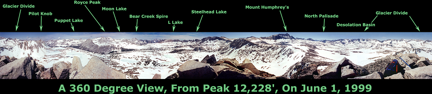
So here is the stretched-out version of my soon-to-be world-famous image. I guess this is for those folks who tend to get dizzy, and don't want to fall off the bottom of the spherical image. There is really nothing for them to worry about. I was camped down there on the bottom, and I didn't fall off. But here you have it anyways:
Picture #469 - copyright © 1999-2014 by John Sherman
I count twenty-four named lakes in my image, and many others besides. There are another four lakes so close to the Peak they are not visible in the image, they are hidden behind the foreground rocks at my feet. You would have to lean out over the edge of the Peak to see them. The north, east, and west faces of the Peak are fairly steep. My tent was on over there beyond Mesa Lake and Lower Desolation Lake, looking over the Upper and Lower Golden Trout Lakes. I was visited by a nice hummingbird the day before I took this picture. I suppose he was very hungry, since there were not very many flowers blooming on this side of the little planet. He was attracted by something red I had out in the sun, which he must have seen from miles away.
There are several peaks visible which are over 14,000' elevation. Those are White Mountain Peak, South Palisade, Middle Palisade, Mt Sill, Polemonium Peak, North Palisade, and Thunderbolt Mtn. They look small because they are far away. Mt Humphreys looks big because it is 13,986' elevation (very nearly 14,000'), and it is closer to the camera. That is why it seems to reach all the way up to the stars above Planet John.
The ridge starting southwest from Peak 12,228' (past my backpack) curves around to the west, and ends at Pilot Knob. The ridge starting southeast curves around to the northeast, and ends where it connects to the Sierra Crest at Four Gables. The part of Desolation Basin south of the ridge and Peak 12,228' is sometimes called Humphrey's Basin. All the water in it drains down Piute Creek Canyon between Pilot Knob and Glacier Divide. Water in the north half of Desolation Basin drains off the lakes plateau and into French Creek. The two creeks merge into one creek and canyon just on the other side of Pilot Knob. From there it all drains over to the ocean, which is on the other side of Planet John from my side. That is where the hummingbird food is.
Picture #470 - copyright © 1999-2014 by John Sherman